The Eastern Algarve: the coast that hides behind a lagoon
Updated September 10, 2026 · 8 min read

Say “Algarve” and most people picture orange cliffs, sea caves and a cove between two rock faces. That Algarve exists, and it lies in the west. The eastern part – Sotavento in Portuguese, the leeward side – looks completely different, and the difference isn’t a matter of style but of geology.
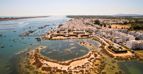
Between Faro and the Spanish border, there’s no rock facing the sea, but water in front of the water: the Ria Formosa, a lagoon separated from the Atlantic by a chain of sand islands. It stretches for around 60 kilometres, covers about 18,400 hectares and has been a nature park since 1987. Five barrier islands – Deserta, Culatra, Armona, Tavira and Cabanas – and two peninsulas, Ancão in the west and Cacela in the east, keep the open sea out.
In practice, that means: most beaches in this area can only be reached by boat. And the boats run on the tides, not on demand.
Here, the tides aren’t a minor detail
On the west coast, low tide just means walking a bit further to reach the water. In the Ria Formosa, it decides whether a trip happens at all. As the water drops, whole areas fall dry; channels that carry a metre of water in the morning are sandbanks by the afternoon.
That’s why departure times for lagoon trips aren’t freely chosen, and why operators reschedule at short notice. That isn’t poor service – it’s the reason the boats don’t run aground. Anyone planning a trip here plans around the water; a tide table for the date in question is the single most useful piece of preparation there is.
The side effect for families is a pleasant one: there’s barely any swell in the lagoon. Anyone who gets seasick on the west coast is often fine here. More on that in Boat trip with kids: minimum age.
Olhão: the market and the three islands
Olhão, a good twenty kilometres west of Tavira, is not a pretty town in the postcard sense, and it’s the most interesting one in the area. The two brick market halls by the harbour are a working market: fish in one, fruit and vegetables in the other, busiest on Saturdays, most honest in the morning.
Boats leave from the quay next door for three islands. Armona is the one with the most houses and the summer village, Culatra has a genuine fishing community with a school and a fire station, Farol is named after the lighthouse at the western end of the same island. No cars run on any of them: anyone who needs to move something pulls a handcart. All three work as a day trip, and it’s the cheapest outing on this coast – the crossings cost a few euros and run all year, though far less often in winter.
The town itself has a cubic building style that looks more North African than Portuguese – flat roofs with terraces, açoteias, where figs used to be dried.
Fuseta, Cacela Velha, Manta Rota
Between Olhão and the border lie three very different places.
Fuseta is a fishing village with a lagoon channel where, at low tide, you can see people wading across to the island – you should only try this with someone who knows the tidal creeks, because the water comes back fast.
Cacela Velha consists of a handful of white houses, a small church and a fortress wall on a cliff above the lagoon. That’s all there is, and it’s one of the most photographed spots in the eastern Algarve. Below lies a sandbank, Praia da Fábrica, to which a fisherman ferries people across when there’s demand – a few minutes’ crossing, cash only, no timetable. Parking is scarce; arrive at eleven in summer and you won’t find any. Places to eat are limited to two addresses, and in winter even those can be closed.
Manta Rota, Altura and Monte Gordo are the exception to the boat rule: from there on, the island chain stops, the beach sits on the mainland, and you walk straight from the car park onto the sand. Monte Gordo is the only place in the east with high-rise buildings, a casino and package-holiday tourism – anyone looking for that will find it there, and anyone avoiding it now knows where it is.
Castro Marim and Vila Real: salt, birds, a grid
Right in the east, where the Guadiana forms the border, lies the Sapal de Castro Marim e Vila Real de Santo António nature reserve: over 2,000 hectares of salt marsh, tidal creeks and salt pans, where around 170 bird species occur regularly – storks, avocets, sandpipers and flamingos in varying numbers. Salt is still harvested here, partly by hand, and it’s the area’s main souvenir.
Above the salt pans stands Castro Marim castle, dating from the 13th century, along with the Forte de São Sebastião from the 17th. From the wall, you can look across into Spanish territory.
Vila Real de Santo António is a special case. The town was thrown up in five months in 1774 on the orders of the Marquês de Pombal, laid out on a strict grid plan modelled on the rebuilt Baixa in Lisbon. Step onto the main square with its black-and-white paving and you’re looking at 18th-century town planning in one piece. A ferry crosses from here to Ayamonte, and over there it’s an hour later – more on that shortly.
Upriver: Alcoutim and the zip line across the border
The Guadiana is the overlooked part of the eastern Algarve. From Vila Real, a road runs about fifty kilometres upriver through empty hill country to Alcoutim, a village with a castle, facing its Spanish counterpart, Sanlúcar de Guadiana, across the water.
A zip line hangs between the two: 720 metres across the river, 70 to 80 km/h, from Spain to Portugal. The best part is a time-zone border: the operator runs on Spanish time, and because Portugal is an hour behind, you technically arrive an hour before you set off.
Anyone who’d rather not jump takes the small ferry boat instead – same route, same time shift, less adrenaline.
The hinterland: Serra do Caldeirão
North of the coast, the land rises into the Serra do Caldeirão, a range of shale hills with cork oaks, rockrose and villages where more people live in winter than in summer. There are walking trails, streams that dry up in summer, and very little signage.
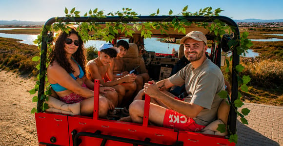
The three-hour jeep tour “Tavira: The Unhurried Algarve — Flamingos, Waterfall & Beach” costs from €79. Its listed location is Tavira; the summary mentions salt pans, a waterfall and a beach, but no route through the Serra do Caldeirão. If the Serra is your goal, confirm the route before booking.
Honestly: what the eastern Algarve is the wrong place for
No sea caves, no towering cliffs, no boat ride into a cave. If those are the images in your head, you need to drive an hour and a half to two hours west – from here, that’s a day trip with a great deal of road.
No surfing. The lagoon protects the coast, that’s its purpose; surf schools are on the west coast.
Barely any nightlife outside Monte Gordo. And through the winter half of the year, some of the boats don’t run, several beach bars close, and some island connections become sporadic.
What the area has instead: warmer water than the west, around 21 degrees in late summer, gently sloping beaches, fewer crowds, shorter drives – and places that are still lived in come February.
Getting around
The Algarve railway line runs the whole length of the east coast, from Faro via Olhão, Fuseta and Tavira to Vila Real de Santo António. It’s slow, cheap, and stops in almost every place worth visiting. So you don’t need a hire car for the coastal towns; for Castro Marim, Alcoutim and the Serra, you do.
What can be booked from Tavira is sorted by type on the pages Ria Formosa Boat Tours, Salt Pans and Flamingos, Food and Wine Tours and Things to Do in Tavira. What the town itself has to offer – the bridge, the castle, the island beaches – is covered in What to See in Tavira, and anyone travelling with kids is better off planning days around Tavira with Kids.